Doggerland (North Sea)
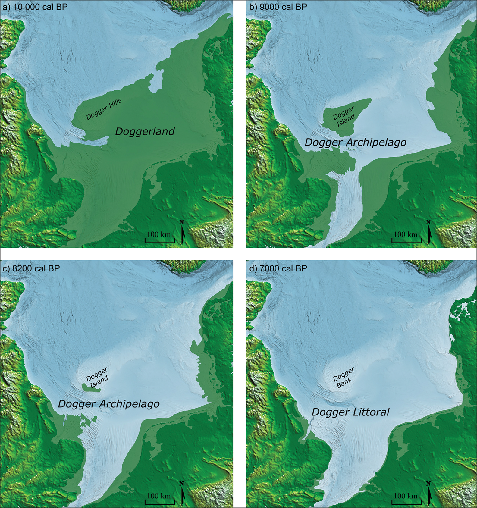
Photo: James Walker, Vincent Gaffney,Simon Fitch,Merle Muru, Andrew Fraser, Martin Bates and Richard Bates, CC BY 4.0, via Wikimedia Commons
Doggerland was a vast landmass that once connected Britain to continental Europe, stretching across what is now the North Sea. This prehistoric landscape, believed to have covered approximately 100,000 square miles at its peak, supported thriving Mesolithic communities for thousands of years before being gradually submerged by rising sea levels. Today, evidence of this lost world lies beneath 20-40 meters of North Sea waters, accessible only through marine archaeology and fishing trawl discoveries. The submerged landscape included river valleys, hills, and coastal plains that would have provided rich hunting and fishing grounds for early human populations.
Timeline
Doggerland reaches its maximum extent as ice sheets retreat, connecting Britain to continental Europe
Catastrophic Storegga Slide tsunami accelerates the submersion process
Final submersion of Doggerland completed as rising sea levels permanently separate Britain from Europe
St. Andrews University researchers announce comprehensive mapping of Doggerland's submerged landscape
What the Show Claims
- ›Doggerland represents the true location of Atlantis, a technologically advanced civilizationS14E13
- ›The submerged landmass housed extraterrestrial visitors who coexisted with ancient humansS14E13
- ›Survivors of Doggerland's destruction migrated to Britain and created megalithic structuresS14E13
- ›The Glastonbury Zodiac was created by Doggerland refugees with alien knowledgeS14E13
From the Transcripts
“The sunken civilization is named Doggerland after a nearby sandbank called Dogger Bank, but there are some who call it by another name: Atlantis.”
What Archaeology Says
Marine archaeological investigations have revealed that Doggerland supported substantial Mesolithic populations, with evidence of sophisticated hunter-gatherer societies adapted to coastal and riverine environments. Fishing trawlers have recovered numerous artifacts from the North Sea floor, including worked flints, bone tools, and fossilized remains of extinct megafauna that once roamed the landscape. The area featured complex river systems, including extensions of major European rivers, creating rich ecosystems that attracted both human settlements and diverse wildlife.
Researchers from institutions including St. Andrews University have used seismic surveys and bathymetric mapping to reconstruct Doggerland's topography, revealing a landscape of rolling hills, river valleys, and extensive coastlines. The submersion process occurred gradually over several millennia, allowing human populations time to adapt and migrate, though catastrophic events like the Storegga Slide tsunami around 8,200 years ago dramatically accelerated the flooding. Archaeological evidence suggests these communities possessed sophisticated maritime technologies and maintained trade networks across the emerging North Sea.
Scientific consensus attributes Doggerland's submersion entirely to natural post-glacial processes, with rising sea levels caused by melting ice sheets at the end of the last glacial maximum. The timeline and mechanisms of this submersion are well-documented through geological and archaeological evidence, with no indication of advanced technologies or sudden catastrophic destruction beyond natural climate events. However, the full extent of human occupation and cultural development in Doggerland remains an active area of research, as underwater archaeology continues to reveal new insights about these lost civilizations.
Mysteries & Fun Facts
Fishing trawlers regularly pull up mammoth bones and prehistoric tools from Doggerland's submerged landscape
The landmass was named after the Dogger Bank, a shallow sandbank that represents one of Doggerland's highest points
At its peak, Doggerland may have supported populations comparable to early Neolithic farming communities
The final separation of Britain from Europe created the English Channel and established Britain as an island nation
Planning a Visit
Doggerland itself cannot be visited as it lies submerged beneath the North Sea, but related exhibitions and artifacts can be viewed at various maritime museums along the British and European coasts. Some specialized marine archaeology tours occasionally offer diving experiences over submerged prehistoric sites, though these are generally limited to experienced divers and researchers.
The submerged landmass lies roughly equidistant from multiple coastal cities, with Norwich, England and The Hague, Netherlands both approximately 100-150 miles from the central area.
Museum exhibitions featuring Doggerland artifacts and reconstructions are accessible year-round. Marine archaeological activities typically occur during summer months when North Sea conditions are most favorable.
Related Sites
Gobekli Tepe
Both represent sophisticated prehistoric civilizations that challenge conventional timelines of human development
Avebury Stone Circle
Ancient Aliens theorists connect Avebury's creators to Doggerland survivors who possessed advanced astronomical knowledge
Callanish Stones / Scottish Sites
Scottish megalithic sites are theorized to have been built by refugees from the submerged Doggerland civilization