Trelleborg Viking Fortress
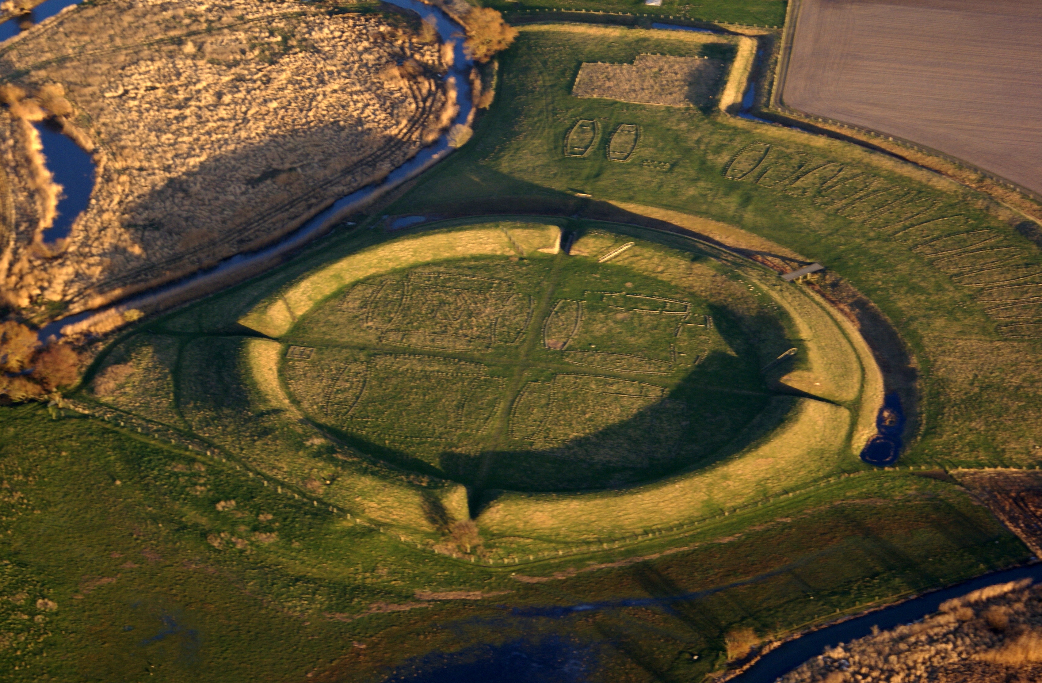
Photo: Thue C. Leibrandt, CC BY-SA 3.0, via Wikimedia Commons
Trelleborg is one of Denmark's most impressive Viking ring fortresses, featuring a perfectly circular rampart approximately 136 meters in diameter with four gates positioned at precise cardinal directions. The fortress consists of a massive earthen wall rising about 5 meters high, enclosing an area of roughly 1.4 hectares where wooden longhouses once stood in geometric formation. Located on Zealand island near the town of Slagelse, this remarkable structure represents the pinnacle of Viking military engineering and urban planning. Today, visitors can walk along the reconstructed ramparts and explore a full-scale replica of a Viking longhouse, experiencing one of the most geometrically precise ancient fortifications in Northern Europe.
Timeline
Construction of Trelleborg fortress during the reign of Harald Bluetooth
Fortress believed to have been abandoned or destroyed
Archaeological excavations begin, revealing the site's geometric precision
Trelleborg Museum opens with reconstructed Viking longhouse
What the Show Claims
- ›The fortress's perfectly circular design and precise alignment with three other Viking fortresses could not have been achieved without advanced surveying technology, possibly indicating extraterrestrial guidanceS03E13
- ›The geometric precision suggests Vikings possessed aerial capability or received guidance from beings with advanced knowledgeS03E13
Theorist Takes
“VON DÄNIKEN: These Viking fortress are in one straight line. You continue the one line straight ahead over the Alps for thousands and thousands of kilometers and under the line always holy places from antiquity, from Stone Age. And the line points directly to Delphi.”
From the Transcripts
“Trelleborg was the starting point 40 miles further another fort appeared. Then he found others, so that there was a line of four forts in Denmark.”
What Archaeology Says
Archaeological investigations at Trelleborg have revealed a masterpiece of Viking-era engineering that challenges traditional assumptions about medieval construction capabilities. Excavations have uncovered evidence of sixteen wooden longhouses arranged in four precise quadrants within the circular rampart, each building positioned with mathematical precision. The fortress walls were constructed using sophisticated earthwork techniques, with timber reinforcement and carefully graded slopes that demonstrate advanced understanding of defensive architecture.
The site is part of a network of similar ring fortresses across Denmark, including Aggersborg, Fyrkat, and Nonnebakken, all built during Harald Bluetooth's reign around 980 AD. These fortresses share remarkably similar dimensions and geometric layouts, suggesting a centralized planning authority with access to standardized architectural knowledge. Archaeological evidence indicates the structures were built quickly and used for relatively short periods, possibly serving as royal power bases or military training centers rather than permanent settlements.
What remains genuinely mysterious is how Viking builders achieved such geometric precision across multiple sites without apparent use of sophisticated surveying instruments known from the Roman world. The fortresses demonstrate a level of mathematical planning and execution that represents either a remarkable indigenous development in engineering knowledge or possible contact with more advanced civilizations. Some researchers propose the Vikings may have employed Roman-trained engineers or inherited knowledge from earlier European traditions, though definitive evidence for such connections remains elusive.
Mysteries & Fun Facts
Trelleborg's circular design is so precise that its diameter varies by less than 2 meters across different measurements
The fortress contained exactly sixteen longhouses, each measuring approximately 29.5 meters in length
All four Viking ring fortresses in Denmark were built using identical geometric principles and proportions
Archaeological evidence suggests the entire fortress was constructed and occupied for less than 30 years
Planning a Visit
The Trelleborg Museum is generally accessible to visitors year-round, offering guided tours of the reconstructed fortress and longhouse exhibits. The site features walking paths along the original ramparts and an interactive museum displaying artifacts from archaeological excavations. Visitors should check the museum's official website for current opening hours and seasonal schedules.
Slagelse is approximately 3 kilometers away, with Copenhagen about 100 kilometers to the northeast.
Late spring through early fall provides the most comfortable weather for exploring the outdoor fortress remains and walking the rampart paths. Summer months offer the longest daylight hours for appreciating the site's geometric precision.
Related Sites
Avebury Stone Circle
Another precisely engineered circular ancient structure that demonstrates advanced geometric planning capabilities
Cahokia Mounds
A sophisticated pre-Columbian settlement showing complex urban planning and astronomical alignments
Thornborough Henges
Three circular earthwork monuments arranged in precise geometric alignment across the landscape