Northumberland Neolithic petroglyphs
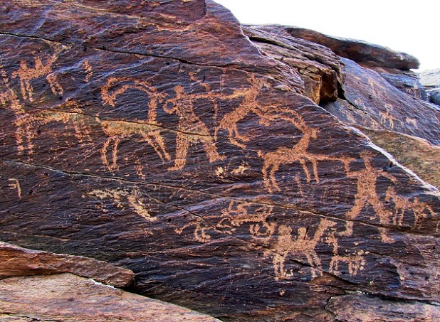
Photo: Asef-m-m, CC BY-SA 4.0, via Wikimedia Commons
The Northumberland petroglyphs represent one of Britain's most extensive collections of prehistoric rock art, carved into exposed sandstone outcrops across the rolling hills of northern England. Visitors today can observe thousands of cup-and-ring marks, spirals, and abstract symbols etched into weathered stone surfaces, with some individual panels containing over 100 separate motifs. The carvings are believed to span approximately 2,000 years of Neolithic and Bronze Age activity, concentrated particularly around areas like Doddington Moor and Roughting Linn. These enigmatic symbols cover an estimated area of several square kilometers, making Northumberland home to one of Europe's richest concentrations of prehistoric rock art. Some theorists have proposed that Northumberland's petroglyphs might encode extraterrestrial messages, citing the possibility of otherworldly communication referenced in scientific literature on the subject. However, archaeologists interpret the cup-and-ring marks and spirals as products of Neolithic ritual practice, ceremonial mapping, or symbolic expression tied to Bronze Age communities' spiritual beliefs and territorial markers—patterns consistent with rock art traditions found across Europe during the same period.
Timeline
Earliest Neolithic petroglyphs carved into Northumberland sandstone outcrops
Peak period of rock art creation during late Neolithic and early Bronze Age
Victorian antiquarians begin systematic documentation of the petroglyphs
NASA/SETI document references Northumberland rock art in discussion of potential extraterrestrial communication patterns
What the Show Claims
- ›Neolithic petroglyphs may constitute a form of extraterrestrial communication following analysis in a 2014 NASA/SETI documentS09E02
- ›The abstract symbols and geometric patterns could encode alien messages preserved in ancient rock artS09E02
Theorist Takes
“I think that we have to start looking at these symbols and ask, how did it originate and from where?”
From the Transcripts
“Singled out in the document are rock art and carvings, including the Neolithic petroglyphs of Northumberland, England.”
What Archaeology Says
Archaeological investigation of Northumberland's rock art began in earnest during the Victorian era, when antiquarians first attempted to catalog and document the extensive petroglyph panels. Modern researchers have employed techniques including laser scanning and digital photography to create detailed records of the carvings, revealing the complexity and variety of the symbol systems used by prehistoric communities.
The scientific consensus suggests these petroglyphs served multiple functions for Neolithic and Bronze Age societies, possibly including territorial markers, ritual or ceremonial purposes, astronomical observations, or even early forms of mapping. The predominant cup-and-ring motifs, often featuring concentric circles with radiating lines, appear across numerous sites in northern Britain and Ireland, suggesting shared cultural traditions or symbolic languages among prehistoric communities.
Despite decades of study, significant mysteries remain about the petroglyphs' precise meaning and purpose. The abstract nature of most symbols makes interpretation challenging, and researchers continue to debate whether the patterns represent star maps, landscape features, spiritual concepts, or something else entirely. Some panels appear to show clear relationships between different symbols, while others seem more random or individualistic in their arrangement.
Recent digital analysis has revealed previously unnoticed details and connections between different petroglyph sites, suggesting more sophisticated planning and coordination than previously understood. However, the fundamental question of what these ancient artists were trying to communicate remains one of British archaeology's most enduring puzzles.
Mysteries & Fun Facts
Some individual petroglyph panels in Northumberland contain over 100 separate carved symbols
The cup-and-ring motifs found here appear across a vast area from Scotland to Spain, suggesting ancient cultural connections
Many of the petroglyphs are only clearly visible under specific lighting conditions, particularly during dawn or dusk
The sandstone used by ancient carvers was ideal for preservation, allowing symbols carved 4,000 years ago to remain clearly visible today
Planning a Visit
The Northumberland petroglyphs are generally accessible to visitors through various walking trails and public footpaths across the region, though many sites require moderate hiking across moorland terrain. Key locations like Doddington Moor and areas near Wooler offer some of the most impressive concentrations of rock art, typically reached via established walking routes.
Newcastle upon Tyne, approximately 50 kilometers southeast
Late spring through early autumn provides the best weather conditions for exploring the exposed moorland sites where most petroglyphs are located. Early morning or late afternoon lighting can enhance the visibility of the carved symbols.
Related Sites
Callanish Stones / Scottish Sites
Features similar Neolithic stone monuments and possible astronomical alignments in the British Isles
Avebury Stone Circle
Another major British prehistoric site with potential astronomical and ritual significance
Carnac Stones
Contains extensive megalithic alignments from the same general Neolithic period as the Northumberland petroglyphs