Cydonia Pyramids, Mars
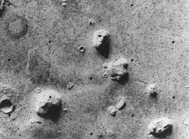
Photo: Viking 1, NASA, Public domain, via Wikimedia Commons
The Cydonia region on Mars contains a collection of mesa formations that captured worldwide attention when photographed by NASA's Viking 1 orbiter in 1976. Located at approximately 40.65° North latitude and 9.5° West longitude, the area spans roughly 25 kilometers across and includes several pyramid-shaped mesas, most notably the D&M Pyramid, which measures approximately 2.5 kilometers at its base. These formations sit within the transitional zone between Mars' northern lowlands and southern highlands, shaped by billions of years of Martian geological processes. The region gained fame not only for these pyramidal structures but also for the nearby "Face on Mars," creating one of the most debated landscapes in the solar system. Ancient astronaut theorists have noted structural similarities between Cydonia's pyramidal mesas and Egypt's pyramids, proposing these formations as evidence of a shared extraterrestrial origin for both civilizations. However, planetary geologists attribute the Martian structures entirely to natural erosion processes—wind and water have shaped the Martian terrain over billions of years, and the apparent geometric regularity of these mesas reflects how uniform erosion patterns can create similar angular features across different celestial bodies. Higher-resolution imaging from subsequent Mars orbiters has revealed irregular surfaces and weathering patterns consistent with natural formation, though the Cydonia region remains a striking example of how terrestrial pattern-recognition can interpret geological processes through cultural expectations.
Timeline
Formation of Martian highland terrain through volcanic and impact processes
Viking 1 orbiter captures first images of Cydonia region, revealing pyramid-like formations
Mars Global Surveyor provides higher-resolution images of Cydonia structures
Mars Reconnaissance Orbiter delivers detailed analysis of geological formations
What the Show Claims
- ›Pyramid-shaped formations in Cydonia match the layout and proportions of Egyptian pyramids at Giza, suggesting artificial constructionS14E02
- ›The D&M Pyramid displays mathematical relationships and geometric precision beyond natural erosion patternsS14E02
- ›Cydonia represents evidence of a lost Martian civilization that influenced ancient Egyptian architectureS14E02
From the Transcripts
“We saw what appeared to be pyramids on the surface of Mars. It's mind-blowing, because these match the pyramids of ancient Egypt.”
What Archaeology Says
Unlike terrestrial archaeological sites, the study of Cydonia relies entirely on orbital imagery and remote sensing analysis. Initial investigations began with Richard Hoagland and the Mars Mission team, who conducted detailed photogrammetric analysis of the Viking images in the 1980s. Independent researchers including Mark Carlotto and Stanley McDaniel applied image processing techniques to enhance the Viking photographs, claiming to identify artificial characteristics in the formations.
NASA's subsequent missions have provided increasingly detailed views of the region. The Mars Global Surveyor's Mars Orbiter Camera captured images with ten times better resolution than Viking, while the Mars Reconnaissance Orbiter's HiRISE camera delivered unprecedented detail. Planetary geologists like Michael Malin have extensively studied these high-resolution images, documenting layered sedimentary rocks and wind-carved features consistent with natural mesa formation.
The scientific consensus attributes the Cydonia formations to typical Martian geological processes. The mesas appear to be erosional remnants of ancient sedimentary deposits, carved by wind over millions of years. The apparent geometric relationships cited by alternative researchers are explained by pareidolia - the human tendency to perceive familiar patterns in random formations - combined with the low resolution and oblique lighting of the original Viking images.
What remains genuinely intriguing is Mars' geological history itself. While mainstream science confidently explains Cydonia's formations through natural processes, the broader questions of ancient Martian climate, potential past habitability, and the planet's geological evolution continue to drive active research and debate within the planetary science community.
Mysteries & Fun Facts
The D&M Pyramid was named after researchers Vincent DiPietro and Gregory Molenaar who first analyzed its geometric properties
Mars' thin atmosphere creates unique erosion patterns that can produce remarkably geometric-looking natural formations
The original Viking 1 images of Cydonia were taken during Martian winter when long shadows enhanced the three-dimensional appearance of the formations
Higher resolution images reveal that the Cydonia mesas are composed of layered sedimentary rocks, indicating they formed in ancient Martian water or wind deposits
Planning a Visit
As Cydonia is located on Mars, direct visitation is currently impossible for civilian tourists. However, the formations can be studied through NASA's publicly available orbital imagery and virtual exploration tools.
No terrestrial cities exist on Mars; the nearest human outpost would be Earth-based space agencies approximately 225 million kilometers away at closest approach.
Mars exploration missions typically target launch windows that occur approximately every 26 months when Earth and Mars are optimally aligned.
Related Sites
Allen Hills, Antarctica (ALH 84001 meteorite find site)
Location where the famous Martian meteorite ALH 84001 was discovered, containing potential evidence of ancient Martian life
Badlands Guardian
Another case of natural geological formations creating artificial-looking patterns visible from above
Tunguska explosion site
Site of unexplained aerial phenomenon that some theorists connect to extraterrestrial visitation