Skellig Michael
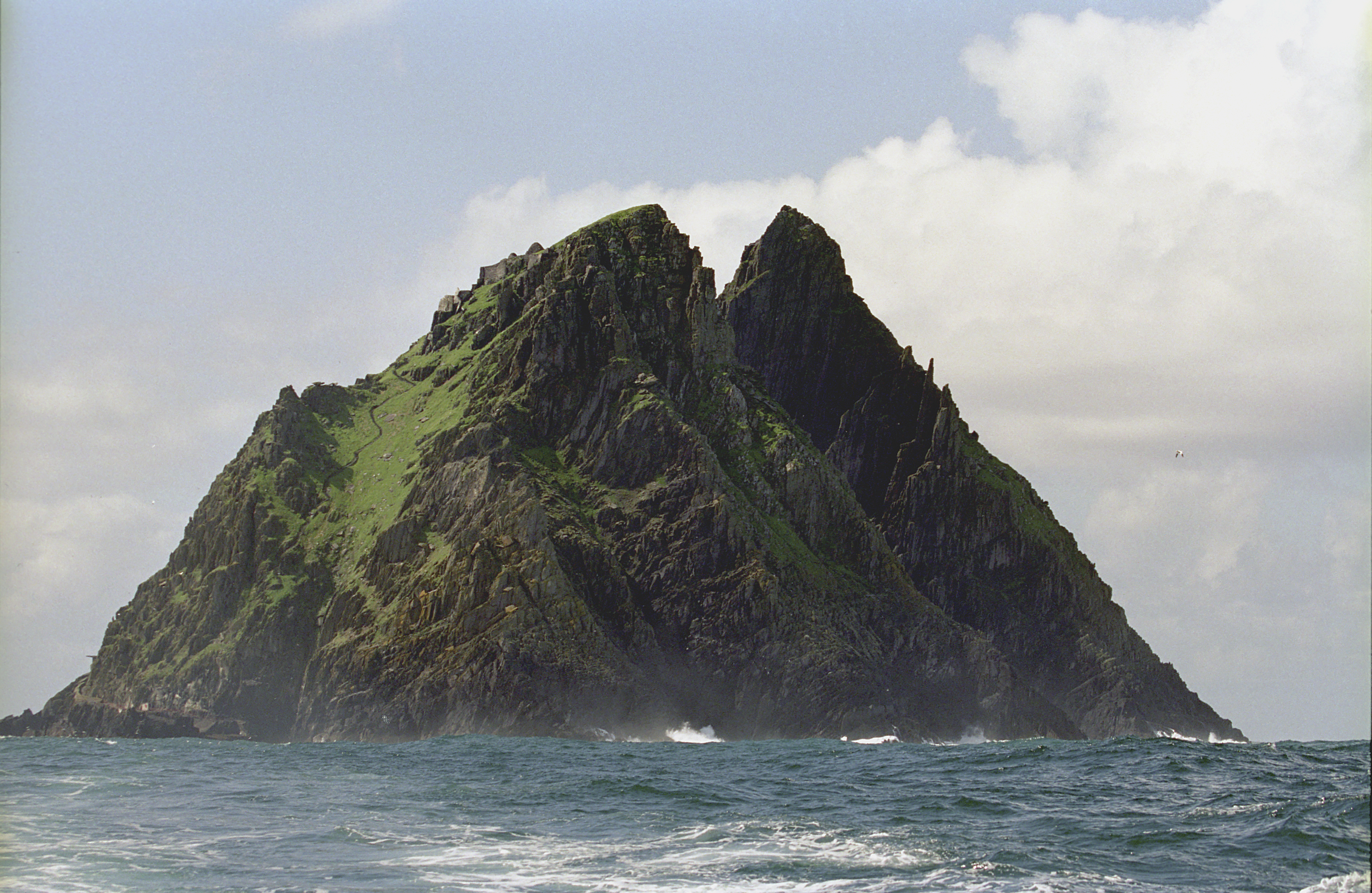
Photo: Jerzy Strzelecki, CC BY-SA 3.0, via Wikimedia Commons
Skellig Michael is a dramatic twin-pinnacled rocky island rising 218 meters above the Atlantic Ocean, located 11.6 kilometers off Ireland's southwestern coast. The island consists of approximately 22 hectares of ancient rock formations dating back 374-360 million years, with steep cliffs and inhospitable terrain that challenged medieval monks who established a monastery on its northern peak. Today, visitors can explore the remarkably preserved 6th-8th century monastic settlement, accessed by narrow stone steps carved into the rock face at elevations between 170-180 meters above sea level. The island's isolation and harsh conditions have preserved both the ancient structures and its diverse wildlife, including puffin colonies and grey seals.
Timeline
Formation of Skellig Michael during mountain-building period alongside MacGillycuddy's Reeks
Irish monks establish Gaelic monastery on the northern peak
UNESCO designates Skellig Michael as World Heritage Site
What the Show Claims
- ›Skellig Michael serves as the western terminus of the St. Michael ley line, a straight alignment of power sites dedicated to the Archangel Michael that extends through Mount Musinè to IsraelS14E15
- ›The monastery's placement suggests coordination with distant sites as part of an ancient network of energy locationsS14E15
Theorist Takes
“You've got this straight line of all these sites, and not just any old sites, power sites. The ancients believed that certain parts of the world were blessed with power, energy, that Musinè is slap-bang on that line.”
From the Transcripts
“One of the most significant ley lines that has been identified is the St. Michael line. Starting from Skellig Michael in Ireland, the seven major sites that lie along this line each have a church dedicated to the archangel Michael, all the way down to the Stella Maris Monastery in Israel.”
What Archaeology Says
Archaeological investigations of Skellig Michael have revealed an exceptionally well-preserved early Christian monastic complex that provides unique insights into medieval Irish religious life. The monastery includes six beehive-shaped stone cells (clochans), two boat-shaped oratories, and various ancillary structures, all constructed using sophisticated dry-stone masonry techniques that have withstood Atlantic storms for over a millennium. The absence of mortar in the construction demonstrates remarkable engineering skill adapted to the island's extreme conditions.
The monastic settlement is situated strategically on the northern peak at elevations of 170-180 meters, connected by an intricate system of stone steps and terraces carved directly into the rock face. Archaeological evidence suggests the community was largely self-sufficient, with carefully engineered water collection systems and small garden plots carved from the rocky terrain. The site's isolation meant that organic materials and structural elements have survived in unusually good condition compared to mainland monasteries.
Scholars attribute the monastery's foundation to the broader movement of Irish monasticism that spread throughout Europe during the early medieval period, with no evidence supporting coordination with distant religious sites. The hermitage on the south peak represents an even more austere phase of monastic life, though its dangerous accessibility limits archaeological investigation. What remains genuinely unknown is the full extent of the community's size over time and the specific reasons for the monastery's eventual abandonment, likely sometime between the 12th and 15th centuries.
Mysteries & Fun Facts
The island's name 'Skellig' derives from the Irish 'sceilig,' meaning splinter of stone
Skellig Michael houses approximately 50 grey seals and serves as a major breeding ground for Atlantic puffins
The monastery's stone steps were carved directly into the rock face and have remained largely intact for over 1,000 years
Christ's Saddle, the valley between the twin peaks, sits at 129 meters above sea level and provides the main access route to the upper monastery
Planning a Visit
Skellig Michael is accessible only during summer months (typically May through October) due to rough Atlantic conditions, with boat trips departing from Portmagee and other Kerry coastal towns. The climb to the monastery involves ascending approximately 600 stone steps carved into the cliff face, requiring reasonable fitness and sturdy footwear. Visitor numbers are strictly limited to protect the fragile archaeological remains and wildlife habitats.
Killarney, approximately 70 kilometers northeast, with boat departures from nearby Portmagee.
Late spring through early autumn offers the best weather conditions and boat accessibility, with July and August providing the most reliable crossings. Early morning departures typically offer calmer seas and better wildlife viewing opportunities.
Related Sites
Avebury Stone Circle
Another European site associated with ancient spiritual energy lines and sacred geography
Externsteine
German rock formation similarly claimed to be positioned along ancient power alignments
Carnac Stones
Megalithic monument in France often connected to theories about prehistoric sacred site networks
Featured In1 episodes
Historical data sourced from Wikipedia