Face on Mars (Cydonia region)
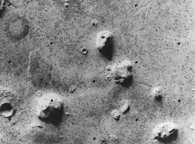
Photo: Viking 1, NASA, Public domain, via Wikimedia Commons
The Face on Mars is a mesa formation located in the Cydonia region of Mars, approximately 2 kilometers long and rising about 800 meters from the surrounding plains. First captured in striking detail by NASA's Viking 1 orbiter on July 25, 1976, this natural landform gained worldwide attention due to its uncanny resemblance to a humanoid face when viewed under specific lighting conditions. The mesa sits at coordinates 40.75°N, 9.46°W on the Martian surface, within a region known for its complex terrain of mesas, buttes, and ancient impact craters. While subsequent high-resolution imaging has revealed it to be a natural geological formation, it remains one of the most famous and controversial landmarks in our solar system.
Timeline
Formation of the Cydonia region mesa through geological processes during Mars' ancient past
Viking 1 orbiter captures the famous 'Face on Mars' photograph on July 25
Mars Global Surveyor takes higher resolution images showing natural mesa formation
Additional detailed Mars Global Surveyor images further confirm natural origin of the formation
What the Show Claims
- ›The Face on Mars is an artificial structure built by an extraterrestrial civilization, supported by fractal analysis showing statistical differences from surrounding terrainS14E02
- ›The formation exhibits high bisymmetry inconsistent with natural geological processesS14E02
- ›Geometric measurements and proportions suggest intelligent design rather than natural erosion patterns
From the Transcripts
“In the summer of 1976, NASA announced that they had found a face on Mars. Now, NASA was the original group of scientists to label the face on Mars a head... it was actually in their file... and they said that they had found this formation on Mars that looked like a face.”
What Archaeology Says
The scientific investigation of the Face on Mars began immediately after the Viking 1 orbiter transmitted the initial images back to Earth in 1976. NASA scientists and geologists quickly recognized the formation as a mesa, a flat-topped hill with steep sides common in arid environments, though the Martian example was far larger than typical terrestrial counterparts. The initial low-resolution image, taken at an oblique angle with specific lighting conditions, created strong shadows that enhanced the face-like appearance through a psychological phenomenon known as pareidolia.
Subsequent missions provided increasingly detailed analysis of the Cydonia region. The Mars Global Surveyor, equipped with high-resolution cameras, captured multiple images of the formation between 1998 and 2001 from different angles and lighting conditions. These images revealed the mesa's true geological nature, showing natural erosion patterns, wind-carved features, and rock stratification consistent with typical Martian landscape formation. Planetary geologists have identified the structure as composed of layered sedimentary rock, likely formed through ancient depositional processes when Mars had a different climate.
The scientific consensus firmly establishes the Face on Mars as a natural landform created through millions of years of wind erosion, thermal cycling, and possibly ancient water flow. Computer modeling and fractal analysis of the high-resolution images demonstrate patterns consistent with natural geological processes rather than artificial construction. However, the formation continues to generate debate among some researchers who argue that certain geometric properties and measurements suggest anomalous characteristics that warrant further investigation.
Despite extensive imaging and analysis, questions remain about the broader Cydonia region and its geological history. The area contains several other interesting formations and mesas that continue to intrigue planetary scientists studying Mars' geological evolution. While the Face itself is understood to be natural, ongoing missions to Mars continue to expand our knowledge of the planet's complex geological processes and ancient environmental conditions that shaped such remarkable landscapes.
Mysteries & Fun Facts
The original Viking 1 image was taken during the Martian late afternoon, creating the dramatic shadows that enhanced the face-like appearance
The mesa measures approximately 2 kilometers in length, making it roughly the size of a large mountain on Earth
Higher resolution images revealed that what appeared to be 'nostrils' in the original photo are actually small hills on the mesa's surface
The Face on Mars helped inspire increased public interest in Mars exploration and contributed to funding for subsequent robotic missions to the planet
Planning a Visit
The Face on Mars remains inaccessible to human visitors, though it continues to be monitored and photographed by various Mars orbital missions. Future Mars exploration missions may eventually provide ground-level imaging and geological sampling of the Cydonia region.
No terrestrial cities exist on Mars; the nearest human settlements are approximately 140 million miles away on Earth.
Currently only accessible through satellite imagery and robotic missions, with optimal viewing dependent on orbital mechanics and seasonal dust storm patterns on Mars.
Featured Locations3 sites within this area
Cydonia Region, Mars
N/A (Mars)The Face on Mars (Cydonia Region)
N/A (Mars)Keyhole formation on Mars (Cydonia region)
N/A (Mars)Related Sites
Badlands Guardian
Another natural formation that resembles a face when viewed from above, demonstrating how geological processes can create anthropomorphic shapes
Tunguska explosion site
A site connected to theories about extraterrestrial events and unexplained phenomena from space
Allen Hills, Antarctica (ALH 84001 meteorite find site)
The location where a Martian meteorite was discovered, providing a direct physical connection between Mars and Earth