Antarctic Pyramids (near Shackleton Mountain Range)
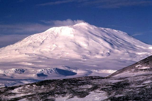
Photo: Richard Waitt, U.S. Geological Survey, Public domain, via Wikimedia Commons
The Antarctic Pyramids refer to several triangular, pyramid-shaped mountain peaks visible in satellite imagery near the Shackleton Mountain Range in Antarctica. These formations, appearing remarkably geometric and symmetrical from aerial views, stand as nunataks — mountain peaks that protrude through the ice sheet. The most prominent of these formations appears to have steep, triangular faces rising approximately 1,200 meters above the surrounding ice, creating an almost perfect pyramidal silhouette against the stark Antarctic landscape. Located in one of the most remote and inhospitable regions on Earth, these peaks are part of the Transantarctic Mountains and remain buried under ice for most of their height.
Timeline
Antarctica becomes covered by ice sheet according to mainstream geology
International Geophysical Year leads to increased Antarctic exploration and mapping
Satellite imagery and Google Earth make pyramid-shaped formations visible to the public
Ancient Aliens explores the formations in "Pyramids of Antarctica" episode
What the Show Claims
- ›Pyramid-shaped formations are artificial structures built by extraterrestrialsS11E01
- ›These may be the oldest pyramids on Earth and the master template for all other pyramids worldwideS11E01
- ›The formations show too much geometric precision to be naturalS11E01
Theorist Takes
“If this gigantic pyramid in Antarctica is an artificial structure, it would probably be the oldest pyramid on our planet. And, in fact, it might be the master pyramid that all the other pyramids on planet Earth were designed, uh, to-to look like.”
From the Transcripts
“In March of 2013, he uncovered what he believes is evidence of yet another pyramid, located just south of Antarctica's remote Shackleton mountain range.”
What Archaeology Says
No formal archaeological excavations have been conducted at these Antarctic formations, as they remain largely inaccessible beneath kilometers of ice and in one of the world's most challenging environments. The extreme conditions, with temperatures regularly dropping below -40°C and fierce katabatic winds, make detailed ground-based investigation nearly impossible with current technology.
Mainstream glaciologists and geologists who have studied the satellite imagery explain these formations as natural nunataks — mountain peaks shaped by millions of years of glacial erosion. The pyramidal shape results from freeze-thaw cycles acting on multiple faces of the peaks, a well-documented geological process that creates sharp, angular mountain forms. Similar naturally occurring pyramid-shaped peaks can be found in other heavily glaciated mountain ranges worldwide.
The scientific consensus holds that Antarctica's ice sheet formation began approximately 34 million years ago, making any surface structures of that age highly unlikely to have been built by any civilization. However, some researchers note that the continent experienced warmer periods in its geological past, and debate continues about the exact timing and extent of ice coverage throughout Antarctica's history.
What remains genuinely unknown is the detailed geological composition and precise formation process of these specific peaks, simply due to their inaccessibility. Future technological advances in remote sensing or ice-penetrating radar might provide more detailed analysis of the formations without requiring physical excavation in this extreme environment.
Mysteries & Fun Facts
The Shackleton Mountain Range was named after Ernest Shackleton, the famous Antarctic explorer
Nunataks, the scientific term for these mountain peaks, comes from the Inuit word meaning 'lonely peak'
Antarctica contains approximately 90% of the world's fresh water, locked in ice
The formations can only be clearly observed through satellite imagery due to their remote location
Planning a Visit
These formations are completely inaccessible to tourists and most researchers due to their location in one of Antarctica's most remote and inhospitable regions. Even scientific expeditions to this area require extensive specialized equipment, international permits, and significant funding.
McMurdo Station, Antarctica (approximately 1,500 kilometers away)
The Antarctic summer months (December through February) offer the only feasible window for any potential scientific expedition, though civilian access remains impossible.
Related Sites
Puma Punku
Features precise stone construction that ancient astronaut theorists claim shows non-human engineering
Sacsayhuaman
Displays megalithic architecture with geometric precision similar to the Antarctic formations' alleged artificial nature
Meroe Pyramids
Represents another pyramid complex that theorists suggest may be connected to a global pyramid-building civilization