The Mystery of the Nazca Lines
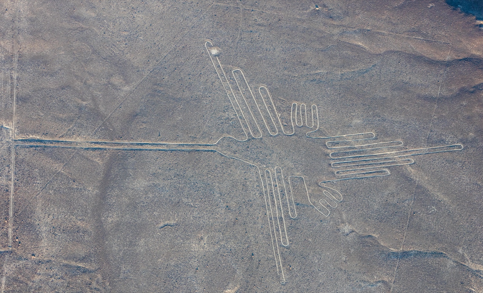
From the road through southern Peru's coastal desert, you'd see nothing. Just pale, flat scrubland stretching toward the Andes — unremarkable, empty, scorched. But from a small plane banking over the Pampa Colorada, the ground suddenly becomes a canvas: a hummingbird with a 93-meter wingspan, a spider the size of a football field, a condor with outstretched wings stretching 130 meters, and hundreds of straight lines running for kilometers without deviation. Some lines are so perfectly straight that surveyors have confirmed they don't vary even over the flattest, most featureless terrain.
Who made them, and why, and — the question that launched a thousand theories — what was the point of art you can only see from above?
The Site
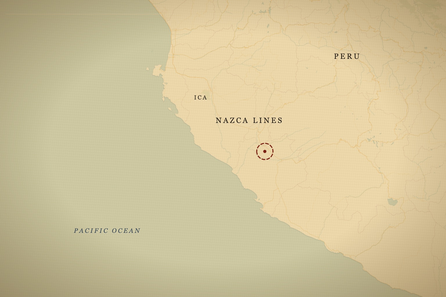
The Nazca Lines cover roughly 450 square kilometers of the Pampa Colorada plateau in Peru's Ica Region, about 400 kilometers south of Lima. The plateau sits at around 600 meters elevation, flanked by the Andes to the east and the Pacific to the west. It's one of the driest places on Earth — less than 10 millimeters of rain per year — which is exactly why the lines have survived at all.
The geoglyphs fall into two main categories: biomorphs (the animal and plant figures — the famous hummingbird, spider, monkey, condor, and about 70 others) and geometric forms (the long straight lines, triangles, spirals, and trapezoids). The largest single figure, a humanoid shape on a hillside, stands roughly 30 meters tall and is visible from the ground. Most of the animal figures cannot be seen in full from any natural vantage point at ground level.
The site is a UNESCO World Heritage Site. You can fly over the main figures on a small charter plane from the town of Nazca — an experience that genuinely makes the scale register in a way that photos never quite do.
What the Show Claims
Ancient Aliens revisits Nazca repeatedly (S1E1 "The Evidence"; S5E8 "Beyond Nazca"). The central argument is the viewing angle problem: why would a pre-Columbian civilization invest enormous labor in creating art that only makes sense from altitude?
The answer the show proposes is that the Nazca Lines were designed to be seen — or used — by beings in the sky. The long straight lines and trapezoidal clearings, when viewed from above, do bear a superficial resemblance to airport runways. The animal figures could be navigational landmarks or tribute symbols directed skyward. The nearby Palpa lines, an older set of geoglyphs on hillsides, feature a humanoid figure with large eyes — the show suggests this depicts an alien visitor.
The logistics argument is also invoked: some lines run straight for kilometers across hills, through gullies, and over uneven terrain. The show suggests this required aerial surveying — that without a view from above, you couldn't ensure the lines stayed true. Erich von Däniken, whose 1968 book "Chariots of the Gods" popularized many of these ideas, spent considerable time on Nazca, calling the lines a "landing strip" in terms that the show has revisited for decades.
The discovery of new geoglyphs using satellite imagery and drones — including the cat figure spotted on a hillside in 2020 — is presented as evidence that the full scope of the lines hasn't been understood, and that more mysteries remain buried in the plateau.
What Archaeology Says
Archaeologists have walked this plateau for a century, and what they've reconstructed is its own kind of astonishing. The Nazca people (roughly 100 BC to 800 AD) made the lines by removing the reddish-brown iron-oxide-coated surface stones and piling them at the sides of the designs, revealing the lighter yellowish-beige earth beneath. The method is deceptively plain — and that's exactly what makes it stranger. Experiments have shown that a team of a few dozen people could produce the lines using wooden stakes, string, and scaled-up grid drawings. No machinery, no altitude. Just hands, sightlines, and a discipline sustained across generations.
Joe Nickell, a researcher at the University of Kentucky, demonstrated in the 1980s that teams could accurately reproduce the most complex Nazca figures using only tools available to pre-Columbian Peruvians. That doesn't shrink the achievement — it relocates the wonder. The straightness of the longest lines comes from sighting along staked strings, the same technique used in land surveying worldwide. Knowing the technique only sharpens the real question: what would drive people to hold a line dead-true for kilometers across gullies and hills, by eye, for something they'd never see whole?
The scientific study of the lines has its own lineage, and it starts with a sunset. American historian Paul Kosok, flying over the pampa in 1941, watched the sun set in alignment with one of the long lines on the winter solstice and called the plateau "the largest astronomy book in the world." His collaborator Maria Reiche — a German-born mathematician — spent the next five decades living beside the pampa, mapping the figures, sweeping them clean with a broom, and paying guards out of her own pocket to keep vehicles off the fragile desert surface. She is the reason the lines survived the 20th century, and she died in 1998 still convinced they encoded a celestial calendar. But in 1968, astronomer Gerald Hawkins — fresh from his computer analysis of Stonehenge's alignments — ran the Nazca lines through the same treatment and found the astronomical correlations no better than chance. The calendar theory largely fell. What replaced it took decades more fieldwork.
As for why — archaeologist Anthony Aveni and colleagues have studied the lines for decades. The strongest thread leads to water. The plateau is a desert, the lines often point toward mountain peaks where snowmelt originates, and many of them seem bound up with an elaborate ritual practice around water and fertility. The lines weren't meant to be flown over; they were walked. The Nazca likely moved along them in ceremonial processions, using them as pilgrimage routes. The biomorphs may represent the spirit animals of specific clans or moieties — though why a clan would render its animal at a scale no walker could ever take in is a question the desert hasn't fully answered.
The pilgrimage reading has physical anchors. At the southern edge of the pampa sits Cahuachi, a sprawling adobe ceremonial center that Italian archaeologist Giuseppe Orefici excavated for more than three decades — a city of temples and plazas with almost no permanent residents, apparently filling and emptying with pilgrims by season. Many lines and trapezoids run toward it. And beneath the desert, the Nazca engineered the puquios — spiral-ramped wells feeding underground aqueducts, some of which still deliver water today; a 2016 satellite study led by Rosa Lasaponara of Italy's National Research Council mapped how the system harvested groundwater year-round from beneath a rainless plain. A people this committed to moving water under the desert, archaeologists argue, plausibly drew on the desert's surface for the same reasons they dug beneath it.
Even the viewing-from-above puzzle stays partly open. Many figures can be seen in full from adjacent hillsides, and the Nazca lived among natural elevated vantage points — but that tells us they could have checked their work, not why they made figures whose entire form resolves only from the air.
And the plateau is nowhere near fully read. Masato Sakai's team at Japan's Yamagata University, which has surveyed Nazca since 2004, announced 143 previously unknown geoglyphs in 2019 — one of them detected by an AI system developed with IBM, the first geoglyph ever found by machine learning. In 2024, the same collaboration published a study in PNAS reporting 303 more figures identified in just six months of AI-assisted survey — nearly doubling the known total in a single campaign. The new detections suggest the smaller, older relief-type figures cluster along footpaths, made to be seen by walkers at ground level. Every discovery sharpens the pampa's split personality: intimate trailside figures pitched at human eyes, and the giant biomorphs that still answer to no vantage point anyone has found.
The Verdict
Archaeology has given us better questions here, not final answers. We know roughly how the lines were made and have a strong lead on what they were for — water, ritual, pilgrimage. The investment of labor was enormous, sustained across generations. The precision of the longest lines is genuinely remarkable for ground-level surveying. And the cat figure discovered in 2019 is a reminder that the plateau is still giving up secrets.
But the thing the lines keep asking stays open. Why render a hummingbird 93 meters across, or a condor with a 130-meter wingspan, in a form whose whole shape no one who made it could ever stand back and see? The water theory tells us why people might have walked these paths. It doesn't quite tell us why the paths had to be a spider, a monkey, a giant bird — figures pitched at a scale that answers to no human eye on the ground. The inner world of the people who walked these lines for centuries is only partially illuminated. There's more to know here than we currently know.
Book the flight. Look down at the hummingbird from 500 feet, and let it ask you its question directly.
Covered On Screen
- Beyond NazcaAncient Aliens · S5 E8
Track the ancient sites you've visited on the interactive map.
Free account · mark visited sites · build your bucket list.
Open the tracker